As a supplier of terrain models, I’ve often been asked about the differences between a terrain model and a topographic map. Both are valuable tools in various fields, including geology, urban planning, and environmental studies, but they serve different purposes and have distinct characteristics. Terrain Model
Physical Representation vs. Two – Dimensional Depiction
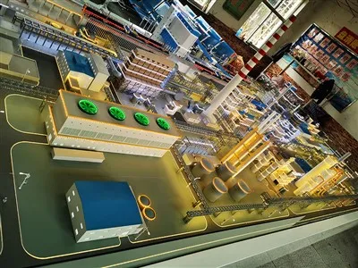
A terrain model is a three – dimensional physical representation of a specific area. It can be made from a variety of materials such as foam, plastic, or resin, and it accurately recreates the physical features of the land, including mountains, valleys, rivers, and plateaus. You can touch, hold, and view it from different angles, which provides a tangible and immersive experience.
On the other hand, a topographic map is a two – dimensional graphic representation of the Earth’s surface. It uses contour lines, symbols, and colors to show elevation, landforms, and other features. While it can provide a lot of information, it lacks the physical presence of a terrain model. For example, when looking at a topographic map, you have to interpret the contour lines to understand the shape of the land. A closely spaced contour line indicates a steep slope, while widely spaced lines represent a gentle slope. But this interpretation requires some knowledge and experience. In a terrain model, the steepness and shape of the land are immediately obvious.
Level of Detail
Terrain models can offer a high level of detail. They can include not only the major landforms but also smaller features such as individual buildings, trees, and even man – made structures like roads and bridges. This detailed representation is especially useful for architects and urban planners who need to visualize how a new building or development will fit into the existing landscape.
Topographic maps, while also detailed, are limited by the scale and the symbols used. Larger – scale maps can show more details, but they cover a smaller area. Smaller – scale maps cover a larger area but sacrifice some details. For instance, a large – scale topographic map of a city might show individual streets and buildings, while a small – scale map of a region will only show major cities and highways.
Usage in Different Fields
In the field of geology, terrain models are often used to study the structure of the Earth’s crust. Geologists can examine the physical relationships between different rock formations and fault lines. They can also use terrain models to simulate the effects of natural disasters such as earthquakes and landslides. A terrain model can help them understand how the land will respond to these events and plan for mitigation strategies.
Topographic maps are also important in geology. They are used to identify the general topography of an area, which can provide clues about the underlying geology. Geologists can use the contour lines on a topographic map to determine the slope of the land and the direction of water flow, which are important factors in understanding the movement of sediment and the formation of rock layers.
In urban planning, terrain models are essential for visualizing proposed developments. Planners can see how a new building will interact with the surrounding environment, including the natural landscape and existing infrastructure. They can also use terrain models to assess the impact of a development on views, sunlight, and wind patterns.
Topographic maps are used in urban planning to understand the existing land use and topography. They help planners identify areas that are suitable for development, as well as areas that may be at risk of flooding or other natural hazards.
Cost and Production Time
Producing a terrain model can be more expensive and time – consuming than creating a topographic map. The materials used to make a terrain model, such as high – quality foam or resin, can be costly. Additionally, the process of creating a terrain model often involves a high level of craftsmanship, especially if it requires a lot of detail.
Topographic maps, on the other hand, can be created relatively quickly and at a lower cost. With the advancement of technology, digital topographic maps can be generated using satellite imagery and geographic information systems (GIS). These maps can be easily updated and shared.
Accuracy and Precision
Terrain models can provide a high level of accuracy, especially when they are created using advanced technologies such as 3D scanning and printing. However, the accuracy of a terrain model can be affected by the quality of the data used and the skill of the model – maker.
Topographic maps are also accurate, but their accuracy depends on the scale and the quality of the data collection. Large – scale maps are generally more accurate than small – scale maps. However, even large – scale maps may have some errors due to limitations in data collection methods.
Educational Value
Terrain models are excellent educational tools. They can help students understand the concept of elevation, slope, and landforms in a more tangible way. For example, in a geography class, students can use a terrain model to study the different types of mountains and valleys. They can also use it to understand how water flows through a landscape.
Topographic maps are also valuable for education. They can teach students how to read and interpret maps, which is an important skill. Students can learn about contour lines, symbols, and scales, and how to use these elements to understand the topography of an area.
Flexibility and Adaptability
Terrain models can be customized to meet specific needs. For example, a terrain model can be made to show a specific time period, such as a historical landscape or a future development scenario. It can also be modified to include additional features or to change the scale.
Topographic maps are more limited in terms of flexibility. Once a map is created, it is difficult to make significant changes. However, digital topographic maps can be updated more easily, but this still requires access to the necessary data and software.
Conclusion
In conclusion, both terrain models and topographic maps have their own advantages and disadvantages. Terrain models offer a three – dimensional, tangible representation of the land, with high levels of detail and the ability to be customized. They are ideal for applications where a physical understanding of the landscape is important, such as in urban planning and geology.

Topographic maps, on the other hand, are two – dimensional, cost – effective, and easy to produce and share. They are useful for providing a general overview of an area and for studying large – scale topography.
Scale Model If you are in need of a terrain model for your project, whether it’s for urban planning, geological research, or educational purposes, we are here to help. Our team of experts can create high – quality terrain models that meet your specific requirements. Contact us to start a discussion about your project and explore how our terrain models can add value to your work.
References
- Bolstad, P. V. (2012). GIS Fundamentals: A First Text on Geographic Information Systems. Eider Press.
- DeMers, M. N. (2015). Fundamentals of Geographic Information Systems. Wiley.
- Slocum, T. A., McMaster, R. B., Kessler, F. C., & Howard, H. H. (2009). Thematic Cartography and Geographic Visualization. Pearson Prentice Hall.
Guangzhou Zonco Culture and Media Co., Ltd.
Guangzhou Zonco Culture and Media Co., Ltd. is one of the most reliable terrain model manufacturers and suppliers in China, also supports customized service with low price. We warmly welcome you to wholesale cheap terrain model from our factory. For quotation, contact us now.
Address: Room C371, 402, Building 6, No.3 Xintang Street, Tianhe District, Guangzhou
E-mail: 13123180052@163.com
WebSite: https://www.scalemodellab.com/